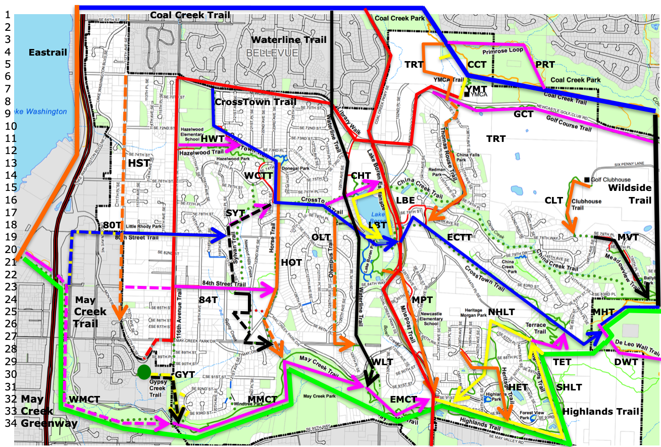
Trail Plan
Trails
| 80th Street Trail | 80T | 18 |
| 84th Street Trail | 84T | 24 |
| China Creek Trail | CHT | 14 |
| Clubhouse Trail | CLT | 16 |
| Coal Creek Trail | CCT | 15 |
| CrossTown Trail | CTT | 8 |
| West CrossTown Trail | WCTT | 14 |
| East CrossTown Trail | ECTT | 19 |
| DeLeo Wall Trail | DWT | 29 |
| Eastrail | EAT | 4 |
| Golf Course Trail | GCT | 9 |
| Gypsy Creek Trail | GYT | 30 |
| Hazelwood Trail | HWT | 11 |
| Heritage Trail | HET | 31 |
| Highlands Trail | HLT | 33 |
| South Highlands Trail | SHLT | 31 |
| North Highlands Trail | NHLT | 25 |
| Hillside Trail | HST | 13 |
| Horse Trail | HOT | 21 |
| Lake Boren Esplanade | LBE | 16 |
| Lake Boren Trail | LBT | 18 |
| Marshall's Hill Trail | MHT | 25 |
| May Creek Trail | MCT | 24 |
| West May Creek Trail | WMCT | 32 |
| Mid May Creek Trail | MMCT | 32 |
| East May Creek Trail | EMCT | 32 |
| Meadowview Trail | MVT | 19 |
| Milepost Trail | MPT | 24 |
| Olympus Trail | OLT | 19 |
| Primrose Trail | PRT | 5 |
| Sylvan Trail | SYT | 17 |
| Terrace Trail | TET | 29 |
| Thomas Rouse Trail | TRT | 11 |
| Waterline Trail | WLT | 3 |
| Wildside Trail | WST | 15 |
| YMCA Trail | YMT | 7 |
Trail Plan
In the map below, trails running west-to-east are shown with blue or magenta lines; north-to-south trails are black or orange. Loop trails are yellow, and sidewalks on major arterials are red. The May Creek Greenway is green. In this map, solid lines are roughly equivalent to the solid and dashed lines in other Newcastle maps: they mark usable pedestrian routes. Dashed lines mark unfinished sections of trails, some usable, some merely proposed. Newcastle trails are shown as arrows: the arrowhead marks the end of the trail. Subtrails are marked by end-to-end arrows of the same color.

