
History
Newcastle
The modern City of Newcastle was founded in 1994, carved from unincorporated King County by residents who wanted more local control as the area was reshaped by development.Newcastle Trails was founded in 1999 by Newcastle citizens who saw the need to preserve community trails and open space. In 2003 it was formally incorporated as a 501(c)3 nonprofit corporation. Since then, NT has played a major role in a small city without a parks department. NT members have advocated for trails and open space, led trail walks, created trail signs, maps and guides, and done much of the needed trail work with volunteer help. Scouts (and parents) from several troops have contributed thousands of volunteer hours to NT work parties.
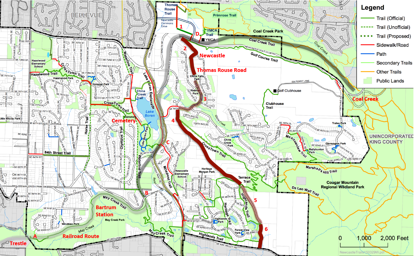
From 1864 to 1963 this was a coal-mining district with two mining towns: Newcastle (just south of the present-day YMCA), and Coal Creek (at the Red Town Trailhead for Cougar Mountain Park), as shown on the map below. By 1878 a railroad ran from Seattle through Renton to Newcastle, extending to Coal Creek by 1883. And in 1880 the Thomas Rouse Road was built to connect Newcastle and its railroad with farms along May Creek. The map below shows historic sites (red labels) and routes (railroad gray, road brown). For details, see Books, Railroad, and Road below.
Books
The book Coals of Newcastle describes Newcastle's early history, illustrated with photos, drawings, and maps. The Newcastle Historical Society has produced a revised and expanded 2020 edition, now available from the King County Library system and Amazon. It's a welcome companion to Eva Lundahl's richly illustrated Trail Book, 14 Shorter Trail Walks In and Around Newcastle, with notes on local history, geology, and wildlife. The Historical Society has been working with the City to place interpretive signs at historic sites along our trails.
Railroad
The Railroad Route is shown on the map in shades of gray, and divided into four segments (A—D). You can walk the route on trails and sidewalks, as follows:
A. Join the Mid May Creek Trail from the Windtree trailhead. Where you reach the old railroad grade, a history kiosk shows photos of the trestle(s) that once spanned May Creek. The trail follows the old roadbed east through cuts and fills. At Bartrum Station, trains stopped for passengers and produce from local farms.
B. Follow the Waterline Trail north to SE 84th Way, and follow the sidewalk past Lake Boren Park to Coal Creek Parkway. For alternate routes, continue north past the Newcastle Cemetery, with graves from the 1800s. Here the West CrossTown Trail runs west past the cemetery and then northwest, following an ox-cart trace still visible in the 1960s. Return to the Parkway through the park, or follow the China Creek Trail around the north end of Lake Boren.
C. Take the Lake Boren Esplanade along the Parkway to Newcastle Golf Club Road (at SE 76th Street). Cross the Parkway and follow NGC Road north to 136th Ave SE, where it curves around to the east. Here 136th heads south on the route of the Thomas Rouse Road, and the main street of old Newcastle.
D. Since the railroad route is blocked east of the YMCA, take the YMCA Trail to the Coal Creek Trail, and head east. Near the end, you'll pass waterfalls and well-marked historic sites. For an alternate route (more history & scenery), turn left before the Y, and follow Newcastle Commons Drive north and west to the Newcastle Monument (history as brick sculpture). Take the Thomas Rouse Trail down to the Coal Creek Trail, head east, and turn left onto the scenic Primrose Trail. It crosses Coal Creek on attractive footbridges, and rejoins the railroad route before the waterfalls and historic sites.
Road
The Thomas Rouse Road is shown on the map above in shades of brown, as part of a walking route with six segments (1-6):
1. The Thomas Rouse Trail is the first segment of the route. The present trail runs from the Coal Creek Trail through Newcastle Commons to the Golf Course Trail on Newcastle Golf Club Road. The Commons makes a fine trailhead, with parking, restaurants, and references to history: the History Display, the Central Square, and the Newcastle Monument.
2. The next segment follows 136th south to China Falls Park. It's a quiet street, shaded by dense woods on both sides, without sidewalks or shoulders. In this area, remnants of old Newcastle – abandoned mineshafts, the old Baima House – provide a singular opportunity for a history park or interpretive facilities. A wooded nature trail could link historic sites. Completing a safe trail-sidewalk route here will complete the Thomas Rouse Trail on segments 1-3 as envisaged in Newcastle's 2019 Comprehensive Plan.
3. This segment is on sidewalks from China Falls Park to the CrossTown Trail, with only two street-crossings. It follows 136th south past Redman Park (across the street) and the Thomas Rouse Road Historic Park. Then it curves west, crossing China Creek near a hidden waterfall, and joining the East CrossTown Trail on SE 79th at SE 79th & 136th opposite Beit Tikvah Church.
4. This walkable segment runs south on 136th, and then follows 144th Place SE (a quiet rural residential road that hugs the hillside) to its junction with the Terrace Trail and Highlands Trail.
5. This segment follows the old road, now overgrown (a proposed trail route). You can detour south on the South Highlands Trail to segment 6.
6. This segment starts at trail sign 91, where the Highlands Trail emerges from an official wetland, turns right onto the old road, and continues to sign 89. Here the trail turns right, and the old road continues straight along a short driveway (legal public access) to May Valley Road.