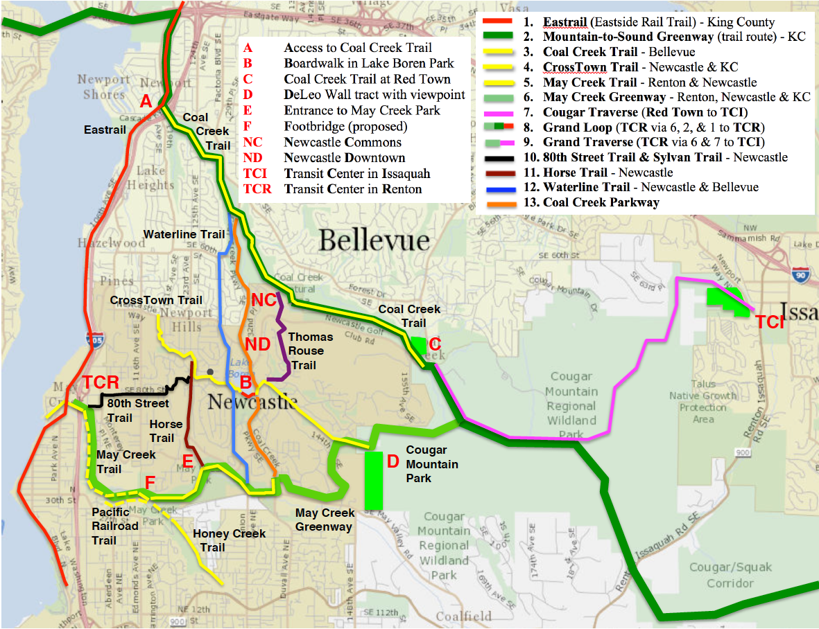
Newcastle-Cougar Trails & Projects
The Newcastle-Cougar Trail Map shows major trails in and around Newcastle and Cougar Mountain,
and identifies current and potential projects along those trails. It also highlights the growing
possibilities for regional trail walks using mass transit. From the transit center in Renton (TCR)
planned for 2024, walkers can follow the May Creek Greenway (when complete) into Cougar Mountain Park
and return via the Coal Creek Trail, doing a grand loop, or do a grand traverse to the transit center
in Issaquah (TCI). For more about Newcastle projects see Ongoing Projects.
1. Regional Trails. The Eastrail (red) is a regional multi-use trail in the Eastside
Rail Corridor. In 2022 a 2.5-mile stretch (paved, 20 feet wide) opened from Bellevue to Renton.
Access (A on the map) for cyclists and pedestrians is provided at 118th Avenue SE and Coal Creek
Parkway. From there the trail continues south past Bellevue's Newcastle Beach Park (just south of A)
to Renton's Kennydale Beach Park and Gene Coulon Memorial Beach Park.
The Mountains-to-Sound Greenway is a 100-mile long corridor along I-90, from the Seattle Waterfront
to Ellensburg, with a network of hiking and biking trails, including the trail route shown in dark
green on the map. This route includes Bellevue's Coal Creek Trail (yellow), running from the I-405
interchange (A) to Cougar Mountain Park at the Red Town Trailhead (C). The trail route from
A to C
and beyond is a series of wooded hiking trails, soft-surfaced, some with steps and footbridges.
Newcastle Beach Park makes an excellent trailhead for the Eastrail and the Coal Creek Trail,
with ample parking near the trail, restrooms, a picnic shelter, and a playground. To reach the
Coal Creek Trail, walk the short distance to the Eastrail, follow it north to the next access,
and follow the sidewalk under I-405 to the current trailhead on 119th Ave SE. To help, Bellevue
could extend the trail to the park and mark it with trail signs.
2. Cougar Mountain Regional Wildland Park. Local citizens have launched three campaigns
to preserve open space areas adjacent to Cougar Mountain Park, all supported by Newcastle Trails (NT)
and the
Issaquah Alps Trails Club (IATC).
Save Cougar Mountain has succeeded: the Bergsma
property (near TCI) has been saved from development and used to expand the park.
Save Coal Creek
asks Bellevue to save the historic Milt Swanson property (C) to preserve a green wildlife corridor
around the Coal Creek Trail at the Red Town Trailhead.
Save DeLeo Wall led a successful effort to
delay the planned logging of a forest parcel (D) in Newcastle, with Newcastle, Renton, and
King County joining forces; but the County's efforts to buy the parcel are stalled (unwilling seller).
IATC is NT's sister organization, older, bigger, and hugely effective: check their website, join,
and support their campaigns.
3. Newcastle Trails. The Newcastle-Cougar map shows only a few of Newcastle's trails.
Newcastle's main west-to-east trails are the
CrossTown Trail (yellow) running SE from Newport
Hills past Lake Boren into Cougar Mountain Park and the
May Creek Trail (yellow) running east
from Lake Washington in Renton to Coal Creek Parkway. The May Creek Greenway includes the May
Creek Trail and parts of other nature trails. The 80th Street & Sylvan Trail
route (black) can be walked on public land almost to the Crosstown Trail.
Three north-to-south routes end at the May Creek Trail. Along with the Windtree Steps
(near F), these routes provide the main entrances to May Creek Park. The
Waterline Trail (blue) and the sidewalks of
Coal Creek Parkway (orange) both run south from the
Coal Creek Trail near the Red Cedar Trailhead. The
Horse Trail (brown) runs south to
the park entrance (E), where the last trail section is being constructed as part of a new
development, the May Creek Park Assemblage.
4. Central Newcastle and Lake Boren Park. Coal Creek Parkway provides a sidewalk
route past Newcastle Commons (NC) to Newcastle's Downtown (ND), two population centers
with apartments, restaurants, and other businesses. It continues past Lake Boren and
Lake Boren Park, which wraps around the south end of the lake. Here the Lake Boren
Boardwalk (B) is planned. When completed in late 2022, it will carry the CrossTown
Trail around the south end of the lake, connecting the main park to its undeveloped
eastern half. Here we can build a trail along the east lakeshore, running north from the boardwalk
and ascending to the Esplanade. This will complete the long-planned
Lake Boren Trail around the lake.
5. May Creek Greenway and Footbridge. The Greenway is complete except for Renton's
part of the May Creek Trail. This section (the West May Creek Trail) is complete from
Lake Washington through the Barbee Mill community to I-405. It will be extended under the
freeway to Jones Ave NE in 2024, when the I-405 interchange is completed. The planned
transit center (TCR) may increase trail use – if trail signs are provided. The May Creek Trail
is invisible where it crossed the Eastrail, and in Barbee Mill it looks like a private trail.
A May Creek Footbridge (F) is needed to complete the May Creek Trail (and the Greenway)
where it crosses from Renton to Newcastle. In 2012, Renton, Newcastle, and King County
formed a partnership to complete the Greenway, and pursued a state grant for the bridge.
The effort failed: although Newcastle completed the Greenway from Renton into Cougar
Mountain Park, a few private parcels are needed to complete the May Creek Trail.
The Pacific Railroad Trail (proposed in Renton's Master Trail Plan) would justify a state (or
county) grant for the footbridge. The trail could be built quickly at any time. It's entirely
within Renton on public land (mostly King County); it's short; and it uses a historic railroad
grade. The benefits of a bridge-trail project are enormous. It would link Kennydale with
Newcastle's trail system. It would give a large and growing population access to both
halves of May Creek Park – at its loveliest point, where the Honey Creek and Gypsy Creek
valleys converge. It might accelerate the completion of trails (a-c) Trails (a-b) rank "highest
priority" in Renton's Master Plan.
a. The Honey Creek Trail is nearly complete from Sunset Boulevard through the
Highlands. Just one easement is needed to extend it to the bridge site.
b. The May Creek Trail can be extended west from the bridge through May Creek Park
without waiting for property acquisition. And only a short initial section (to NE 31st St,
which becomes Jones Ave) is needed to complete a walking/cycling route to the 2024 trail
(Jones Ave to Lake Washington).
c. The Gypsy Creek Trail can be extended north from the bridge to Renton's La Crosse
neighborhood and Kenyon-Dobson Park at any time. It's shared trail (Renton & Newcastle)
entirely on public land.
For more information on (5) see
Linking Renton & Newcastle Trail Systems.
For a 2-page summary (with city comparisons) see
Expanding Renton Trails.