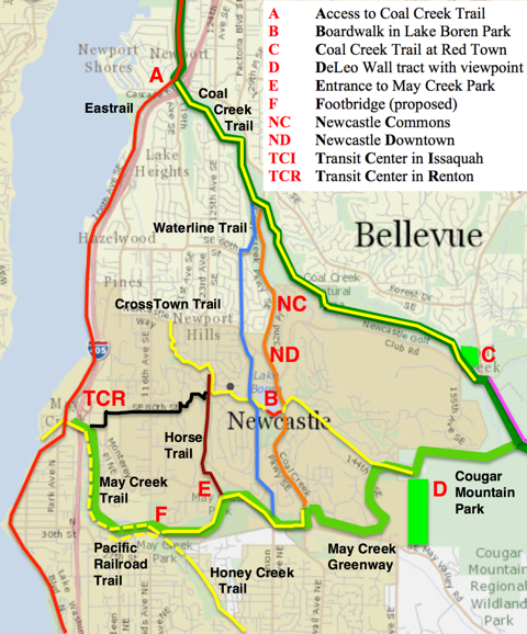
Regional Trails. The map above shows major trails in and around Newcastle. The Eastrail, part of King County’s regional trail system, is a multi-use rail-trail. It's now complete from Coal Creek Parkway (A on the map) to Renton’s Coulon Beach Park (an improved connection is planned). It has good access (A) under I-405 to the Coal Creek Trail. Starting at Newcastle Beach Park (just south of A), you can walk to the Coal Creek Trail and follow it southeast past the Newcastle Commons (NC) to the Red Town Trailhead (C) in Cougar Mountain Park. Park trails connect to the May Creek Greenway, and Greenway trails connect via May Creek Park to the Eastrail. But there’s a gap in this Grand Loop: Renton’s half of the May Creek Trail is incomplete from the planned Transit Center (TCR) to the Newcastle boundary (F), where a footbridge over May Creek is needed. Renton plans to extend the May Creek Trail under I-405 to Jones Avenue in 2024, in conjunction with the new I-405 interchange and Transit Center.
May Creek Footbridge. Given the width of the creek and its flood plain, a footbridge (at F) is a major project (like the Lake Boren Boardwalk) – with a big payoff. A trail-bridge project would link Newcastle’s trail system to Renton’s, and expand May Creek Park. In 2012, Newcastle formed a bridge-building partnership with Renton and King County and pursued a state grant. And failed, as there were no trails on Renton’s side of the bridge. NT proposes a trail-bridge project: reactivate the partnership; build the bridge and a connecting trail in 2024-25. Use trails in Renton’s Master Plan (west of F), extending the May Creek or Honey Creek Trail to the bridge, or building the Pacific Railroad Trail. The first two require an easement or property acquisition; the latter could start now. NT floated this idea in a 2021 talk to the Renton Rotary Club, after discussions with Renton officials. A Renton-Newcastle footbridge is the key to a shared park and trail system of vast extent.
Regional Parkland. NT continues to support efforts to preserve open space adjacent to Cougar Mountain Park.
These include Save Cougar Mountain, which succeeded in adding forest land to the park; Save Coal Creek, working to preserve open space (C)
threatened with development; and
Save DeLeo Wall, working to save a forested hillside (D) containing the DeLeo Wall Viewpoint and several trails.
Save DeLeo Wall has worked successfully with Newcastle, Renton, and King County to prevent logging; efforts to buy the land are continuing.
The other efforts were launched by the Issaquah Alps Trails Association (IATC), NT’s big sister.
We urge you to visit the IATC Website.
Subscribe to their newsletter, and support Save Coal Creek (donate, sign petition, write letters).
Lake Boren Park Boardwalk. The boardwalk project (B) will connect the two halves of
Lake Boren Park with a sequence of paths and boardwalks that will carry the CrossTown and Lake Boren trails on a shared route around the south end of Lake Boren. This will complete the CrossTown Trail on the route shown in Newcastle’s earliest Comprehensive Plan (replacing the detour past the restrooms). The Lake Boren Trail will exist as a trail around the lake, sharing parts of existing trails. It will be complete (per the Plan) when it extends north along the lakeshore, joining the Esplanade (Parkway sidewalk) where the park ends. The Lake Boren Trail is a potential art/history trail that visits historical sites (e.g. the Newcastle Cemetery) and traverses public open space suitable for public art (e.g. the Stone Garden).
Stone Garden. The Stone Garden is a jumble of moss-covered stones in the woods south of the fishing pier. It was noted in the Park Master Plan, and could be developed as a piece of landscape art and/or a memorial garden. It overlaps with the west end of the boardwalk project, where the CrossTown Trail will follow a path through the stones to the first boardwalk. Here, along the path, is a potential site from the Jim Price Memorial, which will likely include a plaque on a stone near the trail.
PSE Powerline Corridor. This utility corridor runs north-to-south a short distance west of Lake Boren, on elevated land with views of the lake and Mount Rainer. In Newcastle, it follows the east edge of the Hazelwood Community, and continues south through Olympus on a public trail easement containing the Olympus Trail. The corridor here is shared by the Olympic Pipe Line Company, which mows the corridor. They helped NT build a section of the trail. PSE’s Energize Eastside wants to enlarge its power transmission line, and the Olympus HOA has opposed it. As a 501(c)3 nonprofit, NT is neutral. We met with the HOA, worked with PSE (discussions and a site visit), and reached an agreement. If and when the line is built, we expect the Hazelwood and Olympus parts of the corridor to be linear mini-parks, with landscaping and trail improvements.
Crosstown Trail.
The City has proposed a trailhead kiosk near Risdon School, and NT has proposed trail signs at the trailhead and other locations (e.g. Beit Tikvah). Peggy Price, NT’s treasurer and trail expert, has led a series of work parties (and Eagle Scout projects) on the East CrossTown Trail for several years now, making improvements and adding new features (e.g the Eagle Scout Aerie, a viewpoint with a bench). We can hold a ribbon-cutting for the trail when the Lake Boren Park Boardwalk and other trail improvements are complete.
Southwest Trails. Aside from Windtree, Southwest Newcastle has been notably deficient in parks and trails. This will soon change, thanks to new subdivisions and City improvements to May Creek Park Drive (west of E). NT worked with planner Dave Van De Weghe and the developers of the May Creek Park Assemblage (E) for an excellent trail result: the Sylvan and Horse Trails will be extended around the west and east sides of the development, joining at May Creek Park Drive. Here a crosswalk will at last provide safe trail access into the park. We worked with planner Erin Fitzgibbons to ensure a good result with the Hiemstra Assemblage on 116th Ave SE, which will include a small park with a playground, sheltered picnic area, grass, woods, trails, and a lookout. We expect the 84th Street Trail to extend west from the Horse Trail through the new park to the Hillside Trail (112th Avenue SE Trail) in Renton, with a trail & sidewalk connection to the May Creek Trail at Jones Road (near TCR). Sidewalks on MCP Drive will improve access to May Creek Park via Renton’s planned Kenyon-Dobson Park (north of F, accessible from 116th) and Windtree (east of F) – where a sidewalk on 121st Ave SE would provide safe sidewalk-trail access to two park entrances: the Windtree Steps (F) and the 91st Street access trail (E). Other projects in this area: ending park encroachment; an access trail from the Vineyard (& Olympus) to the Horse Trail; 91st Street access improvements (two Eagle projects, one by our first girl).
Northeast Trails. In 2021 the Thomas Rouse Trail was completed within Newcastle Commons (NC), from the Coal Creek Trail to Newcastle Golf Club Road. The full trail (as proposed in the Comp Plan) will extend south to the Crosstown Trail along 136th Avenue SE, the north half of the historic Thomas Rouse Road. The trail is complete (on sidewalks) from China Falls south. To fill the gap from the Commons to China Falls, a proper trail would cross two areas: unused woodland owned by the Golf Course (the “boot”); and the Pam and Gary Lee property north of China Falls. The Lee family and the Newcastle Historical Society have worked for years to develop the property in a way that benefits the community, and they may have a win: a single-family development with trails, trees, and the Baima house in a history park. NT looks forward to working with Pam, Historical Society, City and developer for the best possible trail result. In 2021 NT worked with the City on the Hill plat, on the south half of the Thomas Rouse Road (144th Place SE). The development will be buffered from the Road by trees and trails (no direct auto connection).